BY GLENDA TAYONA and IAN PAUL CORDERO
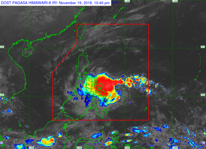
ILOILO City – As tropical depression “Samuel” inches towards Western Visayas, the Regional Disaster Risk Reduction and Management Council (RDRRMC) alerted areas in Iloilo and Guimaras provinces prone to landslide and flood. “Samuel” is projected to make a landfall 40 km west southwest of this city tomorrow morning.
According to Office of Civil Defense (OCD) regional director Jose Roberto Nuñez, “Samuel” may yet become a tropical cyclone.
At around 5:30 p.m. yesterday, the Philippine Coast Guard cancelled the trips of sea vessels plying the Iloilo City – Bacolod City route and vice versa. Coastguard regional spokesperson Lieutenant Commander Ramil Palabrica cited the 5 p.m. weather bullet of the Philippine Atmospheric Geophysical and Astronomical Services Administration (Pagasa) placing Negros Occidental under Tropical Cyclone Warning Signal No. 1.
The lifting of the order cancelling the trips would depend on succeeding weather advisories of Pagasa, said Palabrica.
Meanwhile, as chairperson of the RDRRMC, Nuñez led yesterday’s pre-disaster risk assessment meeting of the council.
There should be “close monitoring” of identified areas in Guimaras and Iloilo, “lalo na mga low-lying areas sa mga barangays na tatamaan ng bagyo,” said Nuñez.
The Mines and Geosciences Bureau (MGB), an attached agency of the Department of Environment and Natural Resources, identified the “top 10” landslide high-risk areas in the region. These were:
* Iloilo – Leon, Tubungan, Igbaras, Miag-ao, San Joaquin, Maasin, Janiuay, Calinog, Lambunao, and Alimodian
* Guimaras – Jordan, San Lorenzo, Buenavista, Sibunag, and Nueva Valencia
* Negros Occidental – Cadiz City, Talisay City, Silay City, Murcia, Escalante City, Don Salvador Benedicto, Himamaylan City, Binalbagan, and La Carlota City
* Aklan – Libacao, Madalag, Malinao, Ibajay, Tangalan, Nabas, Malay, Buruanga, Balete, and Makato
* Antique – Valderrama, Laua-an, Barbaza, San Remigio, Patnongon, Bugasong, Tibiao, Culasi, Sebaste, and Pandan
* Capiz – Tapaz, Jamindan, Maayon, President Roxas, Pilar, Dumarao, Ivisan, Roxas City, Dumalag, and Pontevedra
On the other hand, municipalities and cities more susceptible to flooding were the following:
* Iloilo – Zarraga, Pavia, Dumangas, Leganes, Barotac Nuevo, Pototan, Dingle, San Enrique, Passi City, and Calinog
* Guimaras – Sibunag, Nueva Valencia, Buenavista, San Lorenzo, and Jordan
* Negros Occidental – Bago City, Pulupandan, Valladolid, San Enrique, Pontevedra, Cadiz City, Sagay City, Escalante City, and E.B. Magallona
* Aklan – Kalibo, Numancia, New Washington, Malinao, Banga, Lezo, Madalag, Libacao, Altavas, and Balete
* Antique – Barbaza, Sibalom, San Remigio, Valderrama, Patnongon, Laua-an, Bugasong, San Jose, Tibiao, and Culasi
* Capiz – Dao, Mambusao, Sigma, Sapi-an, Panit-an, Cuartero, Dumalag, Pan-ay, Pontevedra, and Roxas City
According to weather specialist Ronaldo Naragdao of the Philippine Atmospheric Geophysical and Astronomical Services Administration (Pagasa) Iloilo, “Samuel” had a radius of 400 km and this meant inclement weather would be felt throughout the region.
“We just hope and pray na zero casualty tayo,” said Naragdao.
In an 11 a.m. weather bulletin yesterday, Pagasa said “Samuel” was 605 km east of Hinatuan, Surigao del Sur and it was moving northwest at 15 km per hour. Twelve areas were placed under Signal No. 1.
MGB Region 6 chief geologist Mae Magarzo previously said local government units must consult hazard maps when plotting steps to protect their people from geohazards such as landslides and floods./PN


