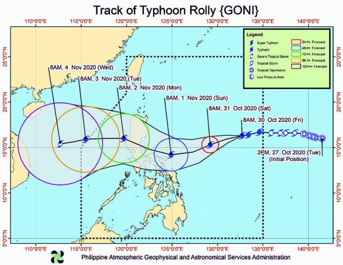
ILOILO City – Potential super typhoon “Rolly” (international name: Goni) is not expected to directly hit Western Visayas, but the Office of Civil Defense is not taking any chances.
Director Jose Roberto Nuñez of OCD-6 urged all local government units across the region to be extra vigilant even while containing the spread of coronavirus disease 2019 (COVID-19).

Nuñez, who also heads the Regional Disaster Risk Reduction and Management Council (RDRRMC) 6, said the region’s 24/7 emergency operation center is currently on “red alert” status.
They are monitoring the weather system because of possible similar hazards brought by typhoon “Quinta” in some provinces in Region 6, Nuñez added.
Heavy rainfall, floods, landslides, and widespread damage to property and agriculture were earlier reported by authorities following Quinta’s onslaught.
Based on the assessment of OCD-6, Western Visayas lost an estimated P31 million in the agriculture sector at the height of typhoon.
“Let’s untiringly aim for zero casualties,” the regional director stressed.
As it continues to gain strength over water, “Rolly” is seen to hit land packing winds with speeds ranging from 185 to 215 kilometers per hour, which could be very destructive, according to the Philippine Atmospheric, Geophysical and Astronomical Services Administration.
“We cautioned the public to prepare and be vigilant against flooding and landslides. We will be monitoring high-risk areas especially landslide-prone areas,” said Nuñez.
Hundreds of people were expected to seek shelter in government-designated evacuation sites or camps ahead of “Rolly’s” landfall, according to Nuñez.
Evacuation sites, he said, should not be filled to full capacity to allow physical distancing among those seeking shelter from the typhoon.
Government shelters are usually crammed with evacuees.
He urged the public to practice wearing facemasks and other personal protective equipment, frequent hand washing and physical distancing.
Today at 10 a.m., Nuñez will convene the members of the RDRRMC-6 for a pre-disaster risk reduction assessment.
“The public and the (local) disaster risk reduction and management councils concerned are advised to take appropriate actions and watch for the next severe weather bulletin,” said Nuñez.
According to its latest track, “Rolly” would make landfall on the Aurora-Quezon area on Sunday (Nov. 1) evening or early Monday (Nov. 2).
The typhoon will likely bring heavy to intense rains over Northern and Central Luzon and Bicol Region, especially those areas along the typhoon’s track.
As of this writing, no locality in the country is currently under Tropical Cyclone Wind Signal (TCWS) No. 1.
Moderate to rough seas (1.2 to 2.5 m) will be experienced over the eastern seaboards of Visayas and Mindanao and the remaining seaboards of Luzon.
Mariners of small seacrafts are advised to take precautionary measures when venturing out to sea.
Inexperienced mariners should avoid navigating in these conditions./PN


