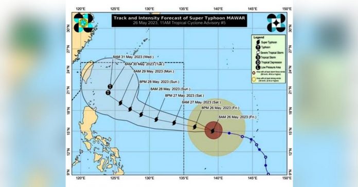
MANILA — Super Typhoon Mawar has slightly intensified as it advanced closer to the border of the Philippine area of responsibility (PAR) on Friday noon, the Philippine Atmospheric, Geophysical and Astronomical Services Administration (Pagasa) said.
In its latest weather bulletin, Pagasa disclosed that Mawar carried maximum sustained winds of 215 kilometers per hour (kph) near the center and gustiness of up to 260 kph. It was last seen 1,705 kilometers east of southeastern Luzon, moving west at the speed of 20 kph. It would be designated the local name “Betty” upon entering the PAR.
According to the state weather bureau’s forecast track, Mawar will enter the PAR between Friday night and Saturday morning (May 27) as a super typhoon and continue moving on a west-northwest pattern eventually likely nearest to the landmass of Luzon between Monday morning and Tuesday morning (May 30).
Mawar is not expected to make landfall, however, as shown in its cone of probability – except when it changes course to slightly swerve lower which may place northern towns of Cagayan on its direct path.
But if it deviates a little to the north from its current track, Pagasa’s models show that Mawar may veer closer instead to Japan’s southernmost islands.
Nevertheless, Pagasa said tropical cyclone wind signals may still be raised since heavy rainfall may be expected over Northern Luzon starting Sunday night or Monday morning.
“In addition, strong to storm-force conditions may be experienced over Extreme Northern Luzon, while strong to gale-force conditions are possible over the northern and eastern portions of Northern Luzon mainland,” the state weather service noted.
“As a result, wind signals will be raised by tomorrow evening in preparation for these severe winds,” it added.
Apart from its own strength, Mawar is seen to enhance the southwest monsoon (locally termed habagat) which may bring rain over the western portions of Central Luzon, Southern Luzon, and Visayas starting Sunday or Monday (May 29). (Gabriel Pabico Lalu © Philippine Daily Inquirer)


